


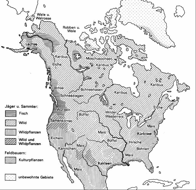
|
| Book cover | Autor | Title | Description |
| Bild | Autor | Leer | Beschreibung |
| Date | Event | Tribe | Chief |
| 7000 BC | From the post-glacial Paleoindian (Plano) period to the Middle Woodland period, aboriginal peoples exploited the local quartz and obsidian deposits, leaving behind an integrated cultural and ecological heritage. | Nipissing (Ojibwe) | - |
| 6000 BC | Around 6000 BC, burial mounds were built in the area of present-day Toronto. | - | - |
| 1000 AD | Nipissing (Ojibwe) Indians lived in villages on what is now Frank's Bay on the southern shore of Lake Nipissing as early as 1000 AD. | Nipissing (Ojibwe) | - |
| About 1450 AD | The Iroquois established a settlement at Crawford Lake in Ontario, Canada. | Iroquois | - |
| 1450 | The Great Dying - It is estimated that around 3/4 million Indians lived on the west coast of what later became the USA, around 2 million on the east coast as far as Florida and around 4 million along the Mississippi. The 'great death' of the Indians took place between 1500 and 1700: - By 1500, about 80% of the Indians had died before the first European explorers reached the coasts of what would later become the USA. Sailors, slave traders and conquistadors introduced diseases - In the first century of the European explorers, i.e. between 1500 and 1600, around 30 million people across the continent died from imported diseases, i.e. around 2/3 of the total population. The population in south-central Mexico fell from 11 million in 1520 to one million in 1650! More than 90% of the people died from diseases imported from the Old World. America in 1600 was probably no longer what it was in 1450. | - | - |
| About 1475 AD | A Wendish settlement was established at the so-called 'Draper Site', about 22 miles north-east of Toronto, about 4 miles north-east of the present-day town of Greensborough. The village had about 2000 inhabitants, was fortified with several palisades and consisted of about 35 longhouses. The village grew steadily over a period of about 50 years as smaller villages in the area were abandoned and their inhabitants moved to the Drapper Site. The village was abandoned at the beginning of the 16th century. All the inhabitants moved to the Mantle Site, about 3 miles northwest of the Drapper Site. | Wendat | - |
| About 1500 | Between about 1500 and 1530, the Wendat inhabited a village ('Mantle Site') of about 17,000 m2 (4.2 acres). The village was inhabited by 1,500 to 2,000 people and was located about 3 km south of Bloomington and about 15 km north-north of Toronto, Ontario. The village consisted of 95 longhouses with an average length of 30 meters and was surrounded by three palisades. Each longhouse was about 30 meters long, 6 meters wide and 6 meters high. The framework of straight and curved wooden poles was covered with dried tree bark. The inhabitants grew corn, beans and pumpkins. Around 1530, the inhabitants left the village and settled in the places known today as Ratcliff and Aurora. | Wendat | - |
| About 1500 | The Neutrals built a fortified settlement south of present-day Iona on the northern edge of Lake Erie, which was inhabited between around 1500 and 1650 AD. An earth wall, which was later reinforced by a second wall, protected around 18 longhouses. Around 800 people are thought to have lived in the settlement. The Neutrals, who emerged as an independent group within the Iroquois culture around 1450, were so called because they did not take part in wars with the traditional rivals of the Iroquois. This neutrality incurred the wrath of the Iroquois Confederacy, and attacks by the Mohawk and Seneca led to the demise of the Neutral nation in 1650. | Neutrals | - |
| About 1500 | Around the same time, a Huron (Wendat) settlement was established northwest of Raven Lake at the confluence of the Talbot River and Perch Creek. The village (Benson Site) consisted of about 25 longhouses and was surrounded by a wooden palisade. The village was inhabited by the Arendahronon Huron ('people of the rock'). | Huron (Wendat) | - |
| About 1500 | Around this time, a Huron village (Wendat) was established on the north-eastern shore of Bass Lake. The village (Sopher Site) was inhabited by the Arendahronon Huron ('people of the rock'). | Huron (Wendat) | - |
| About 1550 | Around 1550, the Wendat established a village (today's 'Aurora Site') on the headwaters of the East Holland River, about two miles west of the present-day village of Vandorf and about 18 miles north of Toronto, Ontario. The village had an area of about 34,000 m2 (8.4 acres) and was heavily fortified with several palisades (!). The Wendat probably left their village about 6 miles to the southeast (the now well-known 'Mantle Site') and built this village. The Rouge River Trail ran through the middle of the village. | Wendat | - |
| 1550-1615 | Around 1550, the Wendat built a village (today's 'Ratcliff Site') with an area of 11,000 m2 (2.8 acres) near the present-day village of Whitchurch-Stouffville. | Wendat | - |
| About 1560 | From about 1560, Hurons (Wendat) lived in a village about a mile northwest of the present-day town of Warminster in Simcoe County, Ontario ('Ball Site'). The village, with an area of about 9 acres (about 37,000 m2), probably consisted of 80 to 90 longhouses. The village was inhabited by the Arendahronon Huron ('people of the rock'). . | Huron (Wendat) | - |
| About 580 AD | Around the same time, a group of Iroquoian-speaking Tionnontate (Wendat) from the Wolf Clan migrated from the north shore of Lake Erie to the area of present-day Avening (about 10 miles south of Georgian Bay). The tribal territory of the Tionnontate between 1580 and 1650 extended roughly from Avening/Creemore in the south to the Blue Mountains at Craighleith on Georgian Bay in the north. The French later called the Tionnontate 'Petun' ('tobacco people'). The Tionnontate were farmers and hunters. They lived in villages that were slightly elevated (for safety reasons and also to be safe from river flooding). Good soil was also important. The Petun changed the location of their villages at regular intervals. The exact origin of the Petun has not been clarified to this day (according to Charles Garrad, 'Petun To Wyandot - The Ontario Petun from the Sixteenth Century'). It was not until 1616, with the visit of Samuel de Champlain and Father Joseph Le Caron to the Petun, that there were written records of the Jesuits and the French about the Petun, which correspond with the archaeological excavations and finds. | Tionnontate (Wendat) Petun (Wendat) | - |
| About 580 AD | Around this time, a group of Iroquoian-speaking Wendat from the Wolf Clan migrated from the north shore of Lake Erie to the area of the present-day village of Avening (about 10 miles south of Georgian Bay). The French later called this group of Wendat 'Petun', also known as Tionnontate ('people among the hills/mountains'). The tribal territory of the Petun between 1580 and 1650 stretched roughly from Avening/Creemore in the south to the Blue Mountains near Craighleith on Georgian Bay in the north. The Petun were farmers and hunters. They lived in villages that were slightly elevated (for safety reasons and also to be protected from flooding by rivers). Good soil was also important. The Petun changed the location of their villages at regular intervals. The Petun cultivated maize, beans and pumpkins on cleared fields. The fields could be cultivated for around 8 to 12 years, after which the soil was exhausted. The exact origin of the Petun has not been clarified to this day (according to Charles Garrad, Petun To Wyandot - The Ontario Petun from the Sixteenth Century). It was not until 1616, with the visit of Samuel de Champlain and Father Joseph Le Caron to the Petun, that there were written records of the Jesuits and French about the Petun, which correspond with the archaeological excavations and finds. | Tionnontate (Wendat) Petun (Wendat) | - |
| About 1580 | Until about 1580, the Rock Tribe Huron (Arendahronon) lived in the Trent River valley, about 70 miles east of Lake Simcoe, and then moved to Huronia in the area of the present-day town of Warminster, northwest of Lake Simcoe. Numerous villages of the Huron Rock Tribe were established in this area. | Arendahronon (Huron) | - |
| 1580 | When the Tionnontate (Wendat) came to Petun County, the Tionnontate (Wendat) traded furs with the Huron (Wendat) for metal cauldrons, glass beads and other goods. The Huron, in turn, brought the furs to Québec once a year and traded them to the French for metal cauldrons, guns and ammunition as well as glass beads. | Tionnontate (Wendat) Huron (Wendat) Petun (Wendat) | - |
| 1589 | Around this time, the third group to arrive in Huronia, who were part of the Huron League, were the Arendahronons, known as the 'people of the rock'. After their arrival, the number of Arendahronons grew steadily as they were joined by other groups from the south. The Arendahronons were still present in the St. Lawrence River valley despite their migration north towards 'Huronia'. It was here that the Arendahronon met Samuel de Champlain in Quebec in 1608/1609 and took part in the Battle of Tocenderoga in 1609. The Arendahronon lived in various villages around Bass Lake in the northwest of Lake Simcoe. | Huron (Wendat) | - |
| About 1590 | From about 1590, Hurons (Wendat) lived in a village about a mile northwest of the present-day village of Warminster in Simcoe County, Ontario ('Warminster Site'). The village consisted of a northern and a southern part (about 165 m apart). Both parts of the village were surrounded by a palisade and probably consisted of more than 100 longhouses. It was the largest Huron village in the region and was visited by Samuel de Champlain on August 17, 1615. The two parts of the village together covered an area of about 15 acres, or approximately 60,000 m2. Sometime between 1616 and 1623, the village was abandoned by the Huron (Wendat). There was probably a lack of firewood and the resources in the area were exhausted. The village was inhabited by the Arendahronon Huron ('people of the rock'). | Arendahronon (Huron) | - |
| About 1600 | The Beaver Valley between present-day Eugenia and Fairmount and the area east of the Blue Mountains was a favorite camping (especially in winter) and hunting ground for the Ottawa Indians for hundreds, if not thousands, of years. When the Petun Indians moved into the area east of the Beaver Valley, the Ottawa began wintering with the Petun. The Ottawa accepted the permanent presence of the Tionnontate (Wendat) in this area. | Ottawa | - |
| About 600 AD | Around the same time, a second group of Iroquoian-speaking Tionnontate ('people among the hills/mountains'), this time the Deer Clan, migrated from the north shore of Lake Erie to the area of present-day Osler Bluff, about 8 km southwest of Collingwood on Georgian Bay. The French called this group of Wendat 'Petun' from around 1632. The tribal territory of the Tionnontate between 1580 and 1650 stretched from Craigmoore in the south to the Blue Mountains at Georgian Bay in northern Ontario. The exact origin of the Petun has not been clarified to this day (according to Charles Garrad, Petun To Wyandot - The Ontario Petun from the Sixteenth Century). It was not until 1616, with the visit of Samuel de Champlain and Father Joseph Le Caron to the Petun, that there were written records of the Jesuits and French about the Petun, which correspond with the archaeological excavations and finds. | Tionnontate (Wendat) Petun (Wendat) | - |
| About 600 AD | Between about 1600 and 1616, the Tionnontate ('people among the hills/mountains') lived in a village in the area of today's Osler Bluff, about 8 km southwest of Collingwood on Georgian Bay. | Tionnontate (Wendat) Petun (Wendat) | - |
| About 1600 | The Petun of the Wolf Clan lived in a village west of Creemore in Ontario. | Tionnontate (Wendat) | - |
| About 1600 | The Petun of the Wolf Clan lived in a village in the northern part of the present-day town of Creemore in Ontario (in the area of the reservoir). | Tionnontate (Wendat) | - |
| About 1600 | The Petun (Wendat) gained access to European trade goods through trade with the Huron (Wendat). The Petun mainly traded with the Huron in the villages of today's 'Ball Site' and 'Warminster Site'. The two Huron villages were located in the Bass Lake area and near Warminster in what is now the province of Ontario. | Petun (Wendat) | - |
| 1609 | It was around this time that the fourth and last group of Indians arrived in Huronia, belonging to the Huron Confederacy. | Huron (Wendat) | - |
| 13 June 1611 | Samuel de Champlain met Etienne Brule again in Quebec after Brule had spent a year with the Algonquin Indians. Brule then returned to the wilderness for four years. It is unclear where Brule stayed, but he probably traveled along the Ottawa River to Lake Nipissing and from there to Huronia. | - | - |
| 29 May 1613Nicht erkannter Quellenhinweis | Samuel de Champlain Expedition 1603-1635 - Champlain left the Sault St. Louis area (Lachine Rapids) near the present-day town of Kahnawake (7 miles southwest of Montreal) and began to sail down the Ottawa River. | - | - |
| June 1613Nicht erkannter Quellenhinweis | Samuel de Champlain Expedition 1603-1635 - Champlain reached Chaudiere Falls near present-day Ottawa. | - | - |
 | |||
| Chaudiere Falls near the present-day city of Ottawa. Source: http://www.torontopubliclibrary.ca/detail.jsp?R=DC-PICTURES-R-805. | |||
| June 1613Nicht erkannter Quellenhinweis | Samuel de Champlain Expedition 1603-1635 - Above the mouth of the Madawaska River, Champlain left the Ottawa River and traveled northwest to Lake Muscrat. | - | - |
| July 1613Nicht erkannter Quellenhinweis | Samuel de Champlain Expedition 1603-1635 - Champlain met the Algonquin Indians at Muscrat Lake. | Algonquin | Nibachis |
| July 1613 | At Muscrat Lake, about 70 miles northwest of Ottawa, Champlain met the Algonquin Indians. | Algonquin | - |
| July 1613Nicht erkannter Quellenhinweis | Samuel de Champlain Expedition 1603-1635 - Champlain reached Lac Allumette. This was the end of his journey in 1613. Tessouät, a chief of the Algonquins, organized a feast in Champlain's honour. There was a stew of crushed corn, chopped fish and meat. Everything was cooked in a pot without salt. Each of the Indian guests brought a spoon and a wooden plate. Champlain, who feared for his health, asked for fish and meat so that he could cook for himself! Champlain then returned to France once more. He would not return to Québec until 1615. . | Algonquin | Tessouat |
| July 1615 | Samuel de Champlain Expedition 1603-1635 - Champlain returned to Québec by ship from France. Father Joseph le Caron accompanied him. From Québec, he made his way to the Hurons and their neighbors, the Tionnontate on Georgian Bay. The route led across the St. Lawrence River and the Ottawa River to Lake Nipissing and Georgian Bay, a tributary of Lake Huron. It took him two months to reach his allies. The many mosquitoes made the journey an ordeal. | Tionnontate (Wendat) | - |
 | |||
| Champlain's Route 1615/1616 Source: http://www.gutenberg.org/files/30257/30257-h/30257-h.htm | |||
| 8 July 1615 | Samuel de Champlain Expedition 1603-1635 - Without waiting for Champlain, the Jesuit priest Joseph Le Caron, some Huronian (Wendish) warriors and 12 other Jesuits set off for Huronia in canoes. | Huron (Wendat) | - |
| 9 July 1615 | Samuel de Champlain Expedition 1603-1635 - Champlain started his expedition to the Hurons in 1615 from Sault St. Louis, near the Lachine Rapids, southwest of Montreal. He accompanied two other Frenchmen, ten Hurons and two fully loaded canoes. | Huron (Wendat) | - |
| Summer 1615 | Samuel de Champlain Expedition 1603-1635 - Champlain reached Chaudiere Falls near present-day Ottawa. | - | - |
| Summer 1615 | Samuel de Champlain Expedition 1603-1635 - Champlain passed Pembroke and rowed on down the Ottawa River towards Lake Nipissing. | - | - |
| 26 July 1615 | Samuel de Champlain Expedition 1603-1635 - Champlain reached Lake Nipissing and camped for two days at the mouth of the Sturgeon River. | - | - |
| 29 July 1615 | Samuel de Champlain Expedition 1603-1635 - Champlain continued his journey on the French River towards Georgian Bay. At the mouth of the French River into Lake Huron (Georgian Bay), the men visited a camp of the Ottawa Indians. According to Champlain, the Ottawa were collecting blueberries to dry for the winter. | Ottawa | - |
| 30 July 1615 | Samuel de Champlain Expedition 1603-1635 - Champlain now paddled south along the eastern shore of Georgian Bay towards Huronia. | - | - |
| 1 August 1615 | Samuel de Champlain Expedition 1603-1635 - Champlain entered what is now Huronia territory on Georgian Bay in Ontario near the Huron (Wendish) village of Toanche (Outoucha) somewhere between Lafontaine Beach and Cawaja Beach. The exact place where Champlain went ashore is not known. Champlain visited more than 10 Huron villages, but only three can be identified with certainty: Tequenonquiaye, Carhagouhaand Cahiague. | Huron (Wendat) | - |
| 2 August 1615 | Samuel de Champlain Expedition 1603-1635 - On his way to the village of Tequenonquiaye, Champlain probably passed through the Huron village of Touagouainchain. | Huron (Wendat) | - |
| 3 August 1615 | Samuel de Champlain Expedition 1603-1635 - Champlain reached the Huron (Wendat) village of Tequenonquiaye. | Huron (Wendat) | - |
| 10 August 1615 | Samuel de Champlain Expedition 1603-1635 - From Tequenonquiaye, Champlain marched to the village of Carhagouha at what is now the southwestern end of Midland Bay near Midland, Ontario. A few days earlier, the Jesuit priest Joseph Le Caron had arrived in this village. The Jesuits called the village Mission St. Joseph. The village was surrounded by a triple wooden palisade about 10 meters high. | Huron (Wendat) | - |
| 12 August 1615 | Samuel de Champlain Expedition 1603-1635 - Father Joseph Le Caron celebrated the first mass in today's Huronia in the village of Carhagouha / Mission St. Joseph. | Huron (Wendat) | - |
 | |||
| Father Joseph Le Caron celebrated the first mass in today's Huronia in the village of Carhagouha / Mission St. Joseph. Source: https://www.shutterstock.com/editorial/image-editorial/art-prints-illustrations-various-6051071hc. | |||
| 14 August 1615 | Samuel de Champlain Expedition 1603-1635 - Champlain and his 10 French colleagues began the march towards the village of Cahiague (Warminster Site). On his way, Champlain visited five Huron villages. All the villages were fortified with wooden palisades. | Huron (Wendat) | - |
| 17 August 1615 | Battle of Syracuse 1615 - Samuel de Champlain Expedition 1603-1635 - Champlain reached the village of Cahiague of the Arendahronon-Hurons (Wendat) in the northwest of Lake Simcoe. This was probably the village now known as the Warminster Site. The village was inhabited by about 5000 people and was probably the largest Huron village in Huronia. Cahiague means 'double village' in the Huron language. From Cahiague, Champlain recruited some Petun warriors for the fight against the Iroquois. After 16 days, Champlain left the Huron village (Wendat) with the Petun and began the march south to attack the Oneida. | Huron (Wendat) | - |
| 1 September 1615 | Battle of Syracuse 1615 - Samuel de Champlain Expedition 1603-1635 - Champlain left the Huron village of Cahiague with 16 Frenchmen and several hundred warriors and set out to attack the Oneida. | Huron (Wendat) | - |
 | |||
| Hurons with birch bark canoes. Source: http://www.geschichteinchronologie.ch/am-N-prim-nations/entw-u-chron/Palomino_indianerholocaust-N-amerika-chron-soziologisch.html. | |||
| 2 September 1615 | Battle of Syracuse 1615 - Samuel de Champlain Expedition 1603-1635 - Champlain reached the narrows between Lake Simcoe and Lake Couchiching ('The Narrows'). The Hurons caught many fish here with wooden fish traps and nets, which were dried for the winter. The Iroquois repeatedly used this isthmus ('The Narrows') between Lake Simcoe and Lake Couchiching as a route through to Huronia to attack the Hurons. | Huron (Wendat) | - |
 | |||
| Fish ladder as used by the Indians. Source: http://muskratmagazine.com/the-secrets-of-the-mnjikaning-fish-weirs/. | |||
| 8 September 1615 | Battle of Syracuse 1615 - Samuel de Champlain Expedition 1603-1635 - In the village of Cahiague, about 500 Huron and Algonquin warriors joined Champlain. | Huron (Wendat) Algonquin | - |
| September 1615 | Battle of Syracuse 1615 - Samuel de Champlain Expedition 1603-1635 - Champlain reached Sturgeon Lake in what is now Ontario. | Huron (Wendat) | - |
| September 1615 | Battle of Syracuse 1615 - Samuel de Champlain Expedition 1603-1635 - Champlain traveled on the Otonabee River to Rice Lake and from there on the Trent River to Lake Ontario. | Huron (Wendat) | - |
| September 1615 | Battle of Syracuse 1615 - Samuel de Champlain Expedition 1603-1635 - At Quinte Bay, the war party crossed Lake Ontario with Champlain. | Huron (Wendat) | - |
 | |||
| Champlain traveling with his Huron allies. Source: Pinterest. | |||
| 18 October 1615 | Battle of Syracuse 1615 - Samuel de Champlain Expedition 1603-1635 - The retreating Hurons and Champlain were caught in a snowstorm. At Lake Ontario, the warriors boarded the canoes they had left behind. Champlain wanted to row some canoes from Lake Ontario back to Québec. But the Hurons did not give Champlain any canoes. So Champlain and the French had to return with the Hurons to Lake Simcoe and spend the winter with the Hurons. | Huron (Wendat) | - |
| 23 December 1615 | Battle of Syracuse 1615 - Samuel de Champlain Expedition 1603-1635 - After the failed attack on the Oneida village, Champlain returned to the Huron village of Cahiague with the Huron and Algonkin warriors. | Huron (Wendat) Algonquin | - |
| 1615 | It is estimated that around 6,500 Tionnontates lived in the area that is now Collingwood. The tribe called themselves the Tionnontate. The Tionnontate lived in 9 villages in a strip about 16 miles wide and about 45 miles deep from Collingwood south of Georgian Bay in Ontario southward to about the level of Lake Eugenia. French missions were established in all the villages after 1616. The names of the villages were (from north to south): - Ekarenniondi (French Mission St. Matthieu near Craigleith) - St. Simon . | Tionnontate (Wendat) | - |
| 1615 | The Tionnontate village of Etarita (site of the later French Mission St. Jean) was located in the area of present-day Springhurst Beach, Ontario. | Tionnontate (Wendat) | - |
| 1615-1630 | About 12 miles south of Collingwood and about a mile west of Creemore was a Tionnontate settlement. Only a few European trade goods were found during excavations in 1926. The village must therefore have existed from around 1615 to around 1630. After 1630, the Tionnontate slowly came into contact with French traders. The Tionnontate villages were protected by palisades. | Tionnontate (Wendat) | - |
| 1615 | When the first Frenchmen (Samuel de Champlain and Father Joseph Le Caron, in January 1616) arrived in the Petun territory, the Tionnontate (Wendat) lived in about eight villages fortified with wooden palisades between Georgian Bay and the present-day town of Creemore. One of the villages was located about a mile east of the present-day town of Glen Huron on the Mad River. The Jesuits gave the village the Christian name Mission St. Andrew. | Tionnontate (Wendat) | - |
| 1615 | At the time of the arrival of the first French in the Petun area (Samuel de Champlain and Father Joseph Le Caron in January 1616), the Tionnontate (Wendat) lived in about eight villages fortified with wooden palisades between Georgian Bay and the present-day village of Creemore. One of the villages was located about a mile southwest of the present-day village of Duntroon. The Jesuits gave the village the Christian name 'Mission St. James'. | Tionnontate (Wendat) | - |
| 1615 | At the time of the arrival of the first French in the Petun area (Samuel de Champlain and Father Joseph Le Caron in January 1616), the Tionnontate (Wendat) lived in about eight villages fortified with wooden palisades between Georgian Bay and the present-day village of Creemore. One of the villages was about a mile east of the present village of Duntroon. The Jesuits gave the village the Christian name 'Mission St. Thomas'. | Tionnontate (Wendat) | - |
| 1615 | When the first Frenchmen (Samuel de Champlain and Father Joseph Le Caron in January 1616) arrived in the Petun territory, the Tionnontate (Wendat) lived in about eight villages fortified with wooden palisades between Georgian Bay and the present-day village of Creemore. One of the villages was located about 1.25 miles north-northwest of the present village of Duntroon, in the area of the source of the Pretty River. The Jesuits gave the village the Christian name 'Mission St. John', the Petun called it Etharita. | Tionnontate (Wendat) | - |
| 1615 | At the time of the arrival of the first French in the Petun area (Samuel de Champlain and Father Joseph Le Caron in January 1616), the Tionnontate (Wendat) lived in about eight villages fortified with wooden palisades between Georgian Bay and the present-day village of Creemore. One of the villages was located about 1.5 miles north-northwest of the present-day village of Duntroon. The Jesuits gave the village the Christian name `Mission St. James`. | Tionnontate (Wendat) | - |
| 1615 | When the first Frenchmen (Samuel de Champlain and Father Joseph Le Caron in January 1616) arrived in the Petun territory, the Tionnontate (Wendat) lived in about eight villages fortified with wooden palisades between Georgian Bay and the present-day village of Creemore. One of the villages was located about 2 miles north-northwest of the present-day village of Duntroon on the Pretty River. The Jesuits gave the village the Christian name of St. Bartholomew. | Tionnontate (Wendat) | - |
| 1615 | Etienne Brule Expedition 1615 - The Frenchman Etienne Brule reached the Seneca (Iroquois) village of Teiaiagon near present-day Toronto on his expedition in 1615. Teiaiagon was one of two villages near present-day Toronto and one of seven villages north of Lake Ontario in Canada. | Seneca (Iroquois) | - |
| Winter 1615/1616 | Samuel de Champlain Expedition 1603-1635 - After the Battle of Syracuse, Champlain spent almost a year with the Hurons in the village of Cahiague, about 10 miles northwest of Lake Simcoe. Champlain observed that the Hurons ate dog meat, bread made from cornmeal and corn on the cob roasted over a fire at feasts. The women did the hard work, while the men only hunted, built huts or went to war. Champlain also criticized the overly strict upbringing of children. The children were never punished and could do as they pleased. | Tionnontate (Wendat) | - |
 | |||
| Reconstruction of a Huron longhouse. Source: http://habitantheritage.org/native_americans/shelter. | |||
| 14 January 1616 | Samuel de Champlain Expedition 1603-1635 - Champlain leaves the Huron village of Cahiague and reaches the village of Carhagouha (Mission St. Joseph). | Huron (Wendat) | - |
| 15 January 1616 | Samuel de Champlain Expedition 1603-1635 - Champlain reached the Huron village of Carhagouha (Mission St. Joseph), where he met Father Joseph Le Caron again. Champlain and Le Caron decided to visit the Petun living west of the Hurons. That same day, Champlain and Le Caron left Carhagouha (Mission St. Joseph) and marched to the Petun. | Huron (Wendat) Petun (Wendat) | - |
 | |||
| Possible route from Champlain 1616 Source: https://www.erudit.org/en/journals/onhistory/2015-v107-n2-onhistory03909/1050633ar.pdf. | |||
| 16 January 1616 | Samuel de Champlain Expedition 1603-1635 - On his way to the Petunia, Champlain probably camped in the area of the Nottawasaga River. | - | - |
| 17 January 1616 | Samuel de Champlain Expedition 1603-1635 - Samuel de Champlain, Father Joseph le Caron and other Frenchmen visited the main village of the Tionnontate near the present-day town of Creemore in Ontario (Melville site). The village was located in the northern part of Creemore, near the present-day reservoir. Champlain spent perhaps a week in this village and about three days in each of the other seven villages he subsequently visited. It is estimated that around 1200 to 1500 people lived in this village. Champlain noted that the Tionnontate were busy building two other villages in the middle of the forest (Sidey-Makay and Hamilton-Lougheed?) at the time of his visit. It is estimated that around 10,000 Tionnontates lived in the 8 or so villages surrounding the Tionnontate village in what is now Creemore. In 1616, the Tionnontate lived in 8 villages and two more villages were under construction. For unknown reasons, Champlain called the Tionnontate 'Petun Nation'. Later, the name 'Petun' was extended to all the tribes in 'Petun County' (the area from Collingwood on Georgian Bay to about Avening/Creemore). When Champlain visited, there were no tobacco fields in the Tionnontate village. The many other Frenchmen who stayed in 'Petun County' also never saw tobacco fields near the Tionnontate. | Tionnontate (Wendat) Petun (Wendat) | - |
| 20 May 1616 | Samuel de Champlain Expedition 1603-1635 - Champlain set off on his return journey to Québec. On June 14, he reached Sault St. Louis, southwest of Montreal. Champlain returned to Québec in July 1616. | Petun (Wendat) | - |
| Summer 1616 | Samuel de Champlain Expedition 1603-1635 - Samuel de Champlain again visited the Ottawa, who lived west of the Hurons, i.e. west of Georgian Bay, in the area of Sault Ste. Marie. | Ottawa | - |
| 1616 | According to the first observations by whites, the Ottawa lived on Manitoulin Island, north of Lake Huron and along the north and south shores of Georgian Bay. | Ottawa | - |
| 1616 | Around 75,000 Indians lived in the Canadian province of Ontario. These Indians were divided into two linguistic and cultural groups: - To the north of Toronto lived around 15,000 Algonquin Indians who, depending on the season, roamed the endless forests and crossed the countless rivers of this region. The Algonquins lived as hunters and gatherers. The most important tribes were the Algonquins and the Montagnais. - About 60,000 Iroquois lived in southern Ontario, living in villages and growing corn, beans and squash. The most important tribes were the Hurons, the Neutrals, the Ottawa and the Petun. | Algonquin Montagnais (Innu) Ottawa Huron (Wendat) Neutrals Petun (Wendat) | - |
| 1616 | The Neutral were the largest group of Iroquois Indians in Ontario and lived in what is now the Hamilton-Niagra District in southern Ontario. To the east of this area, most of the Neutral lived in the area south of Niagara Falls near present-day Buffalo. To the west, the Grand River Valley formed the border, where the Neutrals lived on the Niagara Peninsula and in the present-day cities of Hamilton and Milton. The Neutral population before first contact with Europeans was about 40,000 people, of which between 4,000 and 6,000 were warriors living in 40 villages. At that time, the Neutrals lived in peace with all the surrounding tribes. This is why Samuel de Champlain gave them the name 'Neutrals'. | Neutrals | - |
| 1616 | The Tionnontate ('people among the hills/mountains') left their village in the area of today's Osler Bluff, about 5 miles southwest of Collingwood on Georgian Bay, and moved to a village called Ekarenniondi ('Where the Rocks stands out') near today's Scenic Caves, about 2 miles northwest of the old village. The Tionnontate stayed there until about 1630. | Tionnontate (Wendat) Petun (Wendat) | - |
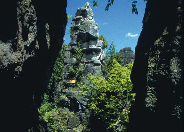 | |||
| Where the Rocks stands out' in today's Scenic Caves near Craigleith, Ontario. Source: https://sceniccaves.com/products/caves-caverns | |||
| 1617 | Around this time, the Petun left their villages near present-day Creemore and settled in the new village of 'Hamilton-Lougheed' northwest of the mouth of the Noisy River into the Bad River, about 3.5 km west of Creemore. The Petun called the village 'Ehwae'. In 1639, French Jesuits founded the Jesuit mission of St. Pierre in the Petun village. | Petun (Wendat) | - |
| End of 1623 | Towards the end of 1623, the village of Carhagouha at what is now the southwestern end of Midland Bay near Midland, Ontario, was abandoned and moved to the west. The new village, named Quieunonascaran, was located on the south shore of the South Basin near the present-day town of Penetang. The Jesuits also named the new village Mission St. Joseph. In 1637, the village consisted of three small villages that were close enough to each other to be recognized as one village, similar to Cahiague (Warminster site). . | Huron (Wendat) | - |
| 1623 | It is estimated that around 10,000 Petun-Hurons already lived in the area of the present-day village of Collingwood (in 1615 there were still an estimated 6,500). | Petun (Wendat) | - |
| 1630 | The Seneca (Iroquois) began to raid the Hurons. Again, the fur trade was the reason. | Seneca (Iroquois) Huron (Wendat) | - |
| 1630 | The Tionnontate (Deer Clan) left their village in the area of today's Scenic Caves and settled in two villages near Craigleith. The Tionnontate remained in this village until about 1650. The name Tionnontate is not known for the smaller of the two villages. The Jesuits called the village Mission St. Simon. | Tionnontate (Wendat) Petun (Wendat) | - |
| 1630 | The Tionnontate (Deer Clan) left their village in the area of today's Scenic Caves and settled in two villages near Craigleith. The Tionnontate remained there until about 1650, when the larger of the two villages took the name of the village near the Scenic Caves, Ekarenniondi. The Jesuits called the village Mission St. Matthieu. | Tionnontate (Wendat) Petun (Wendat) | - |
 | |||
| The two Tionnontate villages near Craigleith, Ontario. Source: Craigleith Heritage Depot 2019. | |||
| 1630-1636 | The Attignaouantan-Hurons (Wends) lived in the village of Ossossane from around 1600 to around 1636. The village consisted of around 40 longhouses with around 1500 inhabitants. About a mile from the village, the Hurons erected an ossuary in 1636 with the bones of about 500 dead Indians. The French missionary Father Jean de Brebeuf witnessed this ceremony. | Attignaouantan Huron (Wendat) | - |
| 1632 | The French recognized that the Tionnontate (Wendat) villages between Creemore and Georgian Bay in Toronto formed a cohesive community. From then on, the French called the Tionnontate (Wendat) Petun. The French mistakenly believed that the Tionnontate (Wends) grew tobacco intensively. The Putun were a South American tribe from whom the French imported tobacco. The French therefore mistakenly referred to the Tionnontate (Wendat) as Putun. When Samuel Champlain traveled to the Petun in 1616, he never once mentioned that the Tionnontate cultivated tobacco. | Tionnontate (Wendat) Petun (Wendat) | - |
| Begin of 1634 | Before the European plagues raged among the Huron (Wendat) and Petun, they together numbered between 30,000 and 35,000 people. The Huron (Wendat) lived east of the Nottawasaga River in 18 villages between Lake Simcoe and Georgian Bay, the Petun west of the Nottawasaga River in 8 villages between Georgian Bay and Avening / Creemore in Ontario. | Huron (Wendat) Petun (Wendat) | - |
| Summer 1634 | The first wave of the epidemic (measles and diarrhea) affected the Hurons (Wendat) and Petun and lasted until the winter of 1634-1635. The mortality rate was around 10%. 'Only' the western Attignawantan Hurons (Wendat) and some Petun were infected. | Huron (Wendat) Petun (Wendat) | - |
| 1634 | French missionaries estimated the population of the Winnebago to be around 25,000 people who lived on the eastern shore of Lake Superior. | Winnebago | - |
| End of June 1636 | The French missionary Father Joseph de la Roche Daillon reaches the village of Toanché of the Huron clan Bear Clan (Wendat). Daillon intended to missionize the Hurons, but failed. On October 18, he set off for the villages of the neutrals. | Huron (Wendat) | Aenon |
| September 1636 | Among the western Attignawantan Hurons (Wendat), an influenza epidemic between fall 1637 and spring 1637 claimed 500 lives, 250 people died in the village of Ossossane alone. In total, between 1300 and 2500 people died among the Huron (Wendat) and Petun. The Nipissing lost 70 people who wintered with the western Wendat (approx. 10% of the total Nipissing population). | Huron (Wendat) Nipissing (Ojibwe) Petun (Wendat) | - |
| End of October 1636 | Father Joseph de la Roche Daillon reached the village of Kandoucho of the Neutral Indians. Kandoucho was one of the 40 (other sources speak of 40) villages of the Neutral Indians. The Jesuits called it the village of All Saints. Like the Hurons, they dissolved their village every five, ten, fifteen or twenty years when the soil was exhausted and moved to a more suitable location, usually 4 to 12 km away. | Neutrals | Tsohahissen |
| 1636 | The French missionary Gabriel Sagard visited the Huron (Wendat) village of Toanché on Nottawasaga Bay in Georgian Bay, Ontario. The exact location of the village is still unknown today. There were probably around 600 Wendat living in the village of Toanché, the chief was Aenon. | Huron (Wendat) | Aenon |
| Summer 1637 | There was another epidemic among the Hurons (Wends) and Petun. The epidemic raged from the summer of 1637 until the fall. The mortality rate was around 10%. At the end of 1637, around 23,000 Hurons (Wends) and Petun were still alive. | Huron (Wendat) Petun (Wendat) | - |
| 1637 | Charles Garnier was the first Jesuit priest to visit the two villages of the Tionnontate (Deer Clan) near Craigleith (Mission St. Simon). | Tionnontate (Wendat) Petun (Wendat) | - |
| Summer 1639 | The Jesuits in New France began to occupy the new central mission Sainte-Marie Among the Hurons (Ste. Marie I). | Huron (Wendat) | - |
| Summer 1639 | Due to fierce attacks by the Iroquois (Seneca) on the Wenro, they left their tribal territory and moved to their allies, the Hurons (Wendat), in the area of Georgisa Bay. Around 600 Wenro arrived in the village of Ossossane of the Huron (Wendat) and were taken in by them. | Wenro Seneca (Iroquois) | - |
| Autumn 1639 | Before the last and strongest wave of the epidemic, around 20,000 Hurons (Wendat) and Petun were still alive. | Huron (Wendat) Petun (Wendat) | - |
| Herbst 1639 - Frühling 1640 | Between summer 1639 and spring 1640, the Hurons (Wends) and Petun were hit by a final severe smallpox epidemic. The French Jesuits counted only around 12,000 surviving Hurons (Wendat) and Petun after the epidemic. Between summer 1634 and summer 1640, the number of Hurons (Wends) and Petun fell from 30,000 to 35,000 to around 12,000! The Petun still lived in 9 villages. | Huron (Wendat) Petun (Wendat) | - |
| 1639 - 1641Nicht erkannter Quellenhinweis | From 1639 to 1641, the Neutrals were ravaged by an epidemic of imported European diseases (smallpox and measles). The number of Neutrals probably fell from around 40,000 to around 12,000. In 1638, a smallpox epidemic broke out in Boston (Massachusetts) and spread as far as Ontario. This population decline, which was documented by French missionaries, had the following effects on the Neutrals: - Population decline: The massive population decline led to a shortage of labor for hunting, agriculture and defense of the territory. - Social destabilization: The Neutrals' traditional way of life collapsed as families and communities were destroyed by the disease. - Weakening of power: The Neutrals lost their supremacy in the region and became more vulnerable to attacks from rival tribes, especially the Iroquois. | Neutrals | - |
| 1639 | The two Petun villages in the Creemore area (Sidey-Mackay Site and Melville Site) were no longer inhabited by the Petun. The survivors of the epidemics raging since 1634 left the two villages and settled in the village of 'Hamilton-Lougheed' (Hamilton-Lougheed Site). | Petun (Wendat) | - |
| 1639 | The Jesuits established the mission of St. Peter and Paul about 9 miles south of present-day Collingwood near Glen Hurin, Ontario. The Petun name for the village was Ehwae ('At the walnut grove'). The Petun left their two villages near present-day Creemore and the two villages near present-day Avening and moved to Mission St. Pierre and St. Paul. This mission was the southernmost Jesuit mission in Ontario. | Petun (Wendat) | - |
| 1639 | The French Jesuits established missions in the four most important Huron villages. A central station was established on the Wye River in the Midland area in the south-east of Georgian Bay, Saint Marie. Saint Marie had to be burned down and abandoned in 1649 due to massive attacks by the Iroquois on the Hurons. In 1647, 18 priests and 24 lay preachers lived in Huronia, one of the main Huron villages. | Huron (Wendat) | - |
| 1639 | The Hurons southeast of Georgian Bay in Ontario, Canada, suffer epidemics in 1636, 1637 and 1639, which are introduced by the French. About half of the Hurons died. | Huron (Wendat) | - |
| 1639 | The attacks by the Iroquois (especially the Mohawk, the northernmost Iroquois tribe) on the Hurons, who had been weakened by epidemics, became increasingly fierce and deadly. The Iroquois now possessed more than 1,000 guns, most of which they received from the Dutch. Between 1626 and 1666, there were 147 Iroquois raids on Hurons and Frenchmen. The motivation for the Iroquois attacks on the Hurons was probably that the French were gaining possession of Huron land. Furs are unlikely to have been the motivation, as the Iroquois only captured furs and other trade goods in 7 of the 147 raids. | Iroquois Mohawk (Iroquois) | - |
| End of 1640 | The village of the Petun Ehwae (Mission St. Pierre et St. Paul) was probably raided by Iroquois and almost completely destroyed. | Petun (Wendat) Iroquois | - |
| End of 1640 | When the Iroquois increasingly raided the villages in the southern tribal area of the Petun (around Creemore) from around 1640, the Petun population continued to decline. As their numbers dwindled, the Petun left their southern villages and moved further and further north towards Georgian Bay. | Petun (Wendat) Iroquois | - |
| 1640 - 1641 | The French missionaries St. Jean de Brebeuf and Chaumonot visited 18 villages of the Neutral (Attiwandaronk) in southern Ontario. They estimated that the Neutral still had about 12,000 inhabitants. In comparison, there were still around 40,000 Neutrals in 1615. The reason for this decline was the introduction of European diseases such as smallpox and measles as well as the constant wars against other tribes. | Neutrals | - |
| 1640 - 1701 | In this protracted war, the Iroquois sought to expand their sphere of influence in order to act as intermediaries in the fur trade between the tribes of the West and the French. It was one of the most brutal wars in American history, and the Mohawk were to take the lead in this struggle. In 1701, the French and Iroquois made peace and the Beaver War was over. | Iroquois | - |
| 1642 | The three Petun villages in the Creemore area (Sidey-Mackay Site and Melville Site) were no longer inhabited by the Petun. By 1642, the last village, 'Hamilton-Lougheed' (Hamilton-Lougheed Site), had also been abandoned. The survivors of the epidemics that had been raging since 1634 moved further north. | Petun (Wendat) | - |
| 1642 | A thousand Seneca and Mohawk raid and destroy part of the Huron villages north of Lake Ontario. | Seneca (Iroquois) Mohawk (Iroquois) Huron (Wendat) | - |
| 1644 | The Iroquois destroyed 15 of the 22 Huron villages and around 10,000 Hurons were killed. | Iroquois Huron (Wendat) | - |
| About 1645 | Saint-Louis was the name given by the Jesuits to the Palisades village of the Ataronchronon tribe of the Huron-Wendat in the 1640s. On the morning of March 16, 1649, the Huron-Wendat village and the Jesuit Mission of St. Ignatius II were attacked by the Iroquois of the Five Nations. | Ataronchronon-Huron (Wendat) | - |
| 1646 | Only now did the French realize that the Tionnontate (Petun) between Creemore and Georgian Bay in Toronto formed a confederation and consisted of two different nations: The Wolf Clan and the Deer Clan. | Tionnontate (Wendat) Petun (Wendat) | - |
| 1647 | The Petun tribe still lived in 5 villages in the state of Ontario. | Tionnontate (Wendat) Petun (Wendat) | - |
| 1648 | The Hurons built the village of St. Ignace II, fortified with a palisade, on an area of 15 acres. | Huron (Wendat) | - |
| About 648 AD | After the Wenro fell out with their former allies, the Neutrals, they were no longer able to defend themselves against the Iroquois and were almost completely destroyed by the Iroquois as a result. | Wenro Neutrals Seneca (Iroquois) | - |
| 16 March 1649 | 1,000 to 2,000 Mohawk and Seneca were hunting beaver in the province of Ontario in the fall of 1848. On their way back, the Iroquois raided the Huron village of St. Ignace II in present-day Simcoe County, Ontario, Canada. As warfare in winter was unusual, the Iroquois managed to take the Hurons by surprise and kill all but 3 of the inhabitants. The 3 survivors ran to the next village, St. Louis. A short time later, the Iroquois appeared there too and destroyed this village as well. After 150 Hurons launched a counterattack on the Mohawk and Seneca, who were forced to retreat with heavy losses, the Mohawk and Seneca retreated southwards. The Hurons panicked. The supremacy of the Hurons in the fur trade collapsed. The Hurons burned down their remaining villages (!) and moved to the two islands in Lake Huron. Without their supplies, thousands starved to death on the two islands. By spring, the Huron tribe had dwindled to a small band. Of the survivors, an entire village surrendered to the Iroquois and was adopted by them, while around 1,000 Hurons joined the Erie, Petun and Neutrals. This mixed race became the Wyandot. A group of about 300 Hurons joined the French in Jeune Lorette near Quebec, where they still live today in their Wendake reservation. These Hurons were given the name Lorette Hurons (or today Wendake Hurons) and were, without exception, loyal allies of the French. Other Hurons moved to the Ottawa. The two French Jesuit priests Father Jean de Brebeuf and Gabriel Lalement were brought by the Mohawk and Seneca from St. Louis to St. Ignatius II and martyred to death by him. | Seneca (Iroquois) Mohawk (Iroquois) Wyandot Huron (Wendat) | - |
| 16 March 1649 | After the attack on St. Ignace II, Mohawk and Seneca attacked and destroyed the Huron settlement of St. Louis. . | Seneca (Iroquois) Mohawk (Iroquois) Wyandot Huron (Wendat) | - |
| 19 March 1649 | After the Iroquois had destroyed the Huron settlements of St. Ignace II and St. Louis, the Hurons (Wendat) in the village of Ossossane suspected that the Iroquois would also attack their village. As a result, the Huron (Wendat) left their village, crossed the frozen Georgian Bay and joined the Petun (Wendat) in their two villages near Craigleith. One of the two Petun (Wendat) villages was Ekarenniondi. . | Iroquois Petun (Wendat) Huron (Wendat) | - |
| 1649 | The Iroquois destroyed the Petun except for a few pitiful remnants. The Petun were allied with the Hurons. After a few battles, the Petun ceased to exist as a tribe. The Hurons who had found shelter with the Petun joined the Ottawa. | Iroquois Ottawa Petun (Wendat) | - |
| 1650 | The Petun tribe still lived in 4 villages in the state of Ontario. | Tionnontate (Wendat) Petun (Wendat) | - |
| 1650 | According to the map of the Jesuit priest Francois DuCreux from 1650, the neutrals were still living in 5 of the original 40 villages at the end of the war against the Iroquois: - St. Michael, probably on the shores of Lake St. Clair, not far from Sandwich and Windsor - Ongiara near Niagara Falls - St. Francis in Lamberton County, east of Sarnia - Our Lady of Angels, west of the Grand River between Cayuga and Haldimand and Paris in Brant County. St. Francis in Lamberton County, east of Sarnia - Our Lady of the Angels, west of the Grand River, between Cayuga in Haldimand County and Paris in Brant County - St. Joseph, in Essex or Kent - St. Alexis, in Elgin, east of St. Thomas. | Neutrals | - |
| About 650 AD | The Suhtai or Sutaio (the later Cheyenne) lived in the area north of Lake Superior. From there they later moved southwest and met the Tsitsista, then living in southwestern Minnesota, around 1665 in the Coteau des Prairies (plateau in the flat prairie of eastern South Dakota, which extends into southwestern Minnesota and northwestern Iowa). They merged at the end of the 19th century to form the Cheyenne of today. | Cheyenne Suhtai (Cheyenne) | - |
| 1651 | The Seneca (Iroquois) took in up to 1,000 surviving Hurons, who even lived in their own Huron village in Gandougarae. Around 700 Hurons lived among the Mohawk, once their fiercest enemies. | Seneca (Iroquois) Huron (Wendat) Mohawk (Iroquois) | - |
| 1651 | The Iroquois started a war against the Neutrals (Attiwandaronk), who lived on Lake Ontario and Lake Erie. After a successful counterattack by the Neutrals, the tribe disbanded by 1653. The Neutrals were practically wiped out, all 18 villages destroyed. Again, many of the surviving Neutrals were adopted by the Iroquois. With wars of extermination against tribes such as the Petun, Neutral and Erie, the Iroquois wanted to prevent them from inheriting the former trading power of the Hurons. | Iroquois Neutrals Huron (Wendat) | - |
| 1655 | Until 1655, the Neutral lived in a village (probably) on today's Forty Mile Creek near Grimsby. Until 1655, the Neutral buried their dead in a nearby burial ground. In 1976, the remains of more than 373 people were found in 31 individual graves and 24 multiple graves. The remains were typically accompanied by a variety of grave goods, including carved combs, pipes, pottery, beads and European trade goods from the mid-17th century. After 1655, Iroquois pressure became too strong and the village was either abandoned or destroyed by the Iroquois. | Neutrals | - |
| 1655 | The Iroquois no longer fought against the Indians, but against the French. For the next ten years, no Frenchman could leave his post without fearing for his life. The very existence of the French colonies was threatened. It was not until 1666 that the French began to defend themselves against the Iroquois in an organized and military manner. | Iroquois | - |
| 1658 | After the Mohawk had fought and defeated almost all the surrounding tribes, only the Sokoki, Penacook and Pocumtuc remained. The Mahican were forced to leave the alliance in 1658 and conclude a separate peace with the Mohawk. | Mohawk (Iroquois) Sokoki (Abenaki) Penacook (Abenaki) Pocumtuc | - |
| 1665-1701 | The Iroquois established seven villages north of Lake Ontario between 1665 and 1770. There were no more beavers in the Iroquois homeland in New York State between 1640 and 1650. The Iroquois competed with the Huron, Ottawa and Algonquin for the fur trade. With the establishment of the seven villages, the Iroquois took control of the fur river from this area to Albany and Montreal, the two main centers of the fur trade. The seven villages were: - Ganneious - at the site of present-day Napanee - Kente - at Quinte Bay - Kentsio - at Rice Lake - Ganaraske - at the site of present-day Port Hope - Ganatsekwyagon - at the mouth of the Rouge River - Teiaiagon - at the mouth of the Humber River - Quinaouatoua (or Tinawatawa) - near present-day Hamilton. At the same time as expanding northwards, the Iroquois began to extend their territory into what is now Ohio, Pennsylvania and Quebec. | Seneca (Iroquois) Cayuga (Iroquois) Oneida (Iroquois) | - |
| About 1665 | The Jesuit priest René de Brehand de Galinee noted on his map in 1655 that the Nipissing (Ojibwe) Indians lived in a village in what is now Frank's Bay. | Nipissing (Ojibwe) | - |
| 1665 | Around this time, the Seneca established the village of Quinaouatoua (or Tinawatawa) near the present-day city of Hamilton. Quinaouatoua was one of seven Iroquois villages north of Lake Ontario in Canada. It was one of the smaller villages, with about 100 people still living in the village in 1669. The village was an important fur trading post and part of the regional power struggle between the French, British and Iroquois. | Seneca (Iroquois) | - |
| 1665 | Around this time, the Cayuga established the village of Ganaraske near the present-day city of Hamilton. Ganaraske was one of seven Iroquois villages north of Lake Ontario in Canada. The village was an important fur trading post and part of the regional power struggle between the French, British and Iroquois. | Cayuga (Iroquois) | - |
| 1665 | Around this time, the Cayuga established the village of Kentsio near present-day Rice Lake. Kentsio was one of seven Iroquois villages north of Lake Ontario in Canada. The village was an important fur trading post and part of the regional power struggle between the French, British and Iroquois. | Cayuga (Iroquois) | - |
| 1665 | Around this time, the Cayuga established the village of Kente near present-day Rice Lake. Kente was one of seven Iroquois villages north of Lake Ontario in Canada. The village was an important fur trading post and part of the regional power struggle between the French, British and Iroquois. | Cayuga (Iroquois) | - |
| 1665 | Around this time, the Seneca established the village of Ganneious at the mouth of the Napanee River in the Napanee area. Ganneious was one of seven Iroquois villages north of Lake Ontario in Canada. From the seven villages north of Lake Ontario, the Iroquois hunted beaver and other wild animals. The Iroquois used these villages to control the fur trade from the north and west to the fur markets near Albany. | Oneida (Iroquois) | - |
| 1665 | Around this time, the Seneca established the village of Ganatsekwyagon near present-day Toronto on the banks of the Rouge River near the present-day Glen Rough Campground. Ganatsekwyagon was one of two Seneca villages near present-day Toronto and one of seven Iroquois villages north of Lake Ontario in Canada. About 500-800 people lived in the village. The village was an important fur trading post and part of the regional power struggle between the French, British and Iroquois. | Seneca (Iroquois) | - |
| 1668 | The Frenchmen Claude Trouve and Fran?ois de Fenelon established the Kente (Quinte) mission at the request of the Cayuga (Iroquois). The mission was abandoned in 1680. | Cayuga (Iroquois) | - |
| 1668 | An English ship finds the sea route to Hudson Bay and begins a lucrative trade with the Cree Indians on the southern shore of Hudson Bay. In 1670, the Hudson's Bay Company was granted trading rights and began building forts and trading posts along Hudson Bay. Nevertheless, most of the fur trade remained in the hands of the French. The Indians' hunting grounds were located hundreds of kilometers west of Hudson Bay and the route from the hunting grounds to Hudson Bay led through areas poor in game, the `Starving Country`. Nevertheless, the beginning of English trading activities in Hudson Bay also laid the foundation for the later conflicts between France and England in North America. | Cree | - |
| Winter 1669 | The missionary Fran?ois de Salignac de la Mothe-Fénelon spends the winter of 1669/1670 in the Seneca village of Ganatsekwyagon at the confluence of Little Rouge Creek and Rouge River near present-day Toronto, Ontario. | Seneca (Iroquois) | - |
| 1671 | At Keneewah Bay in Wisconsin, the Ottawa were once again harassed by the Sioux. The missionaries in the Ottawa village promised to protect them. As a result, the Ottawa returned to Manitoulin Island. By 1680, the Ottawa had already left the peninsula again and moved to Mackinaw. | Ottawa | - |
| 12 July 1672 | The French founded Fort Frontenac at the mouth of the Cataraqui River in Lake Ontario, near present-day Kingston (Ontario). Frontenac negotiated here with the Iroquois to make the fur trade palatable to them. In 1814, after the Tecumseh War, the fort was razed and built over. | Iroquois | - |
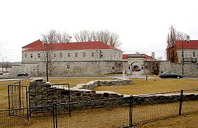 | |||
| Replica of Fort Frontenac near Kingston on Lake Ontario in Canada - Source: http://en.wikipedia.org/wiki/Fort_Cataraqui. | |||
| 1679 | The Frenchman Rene-Robert Cavelier built Fort Conti north of Niagara Falls, which was later renamed Fort Niagara. Fort Conti was destroyed again and replaced by Fort Denonville. In July 1759, the fort fell into the hands of the British during the Indian War. After the Peace of Paris in 1783, Fort Niagara was located on American territory and had to be evacuated by the British. | - | - |
| 1683 | The French sent military troops to North America for the first time to protect the settlements! As early as 1685, 1600 soldiers were stationed to protect the approximately 11,000 settlers, farmers, traders and fishermen. Of these settlers, only around 1/4 were men between the ages of 16 and 60, which is why the military dominated society and shaped everyday life. The military units were divided into individual, independent companies of around 50 soldiers with a captain as leader, a lieutenant and 4 other leaders. | - | - |
| 1686 | The Iroquois attacked Fort Frontenac and burned it to the ground. After this attack, there was a tense peace between the French and the Iroquois until King William's War in 1689. | Iroquois | - |
| 1696 | The Iroquois were gradually pushed back by the Ojibwe from the territory that the Huron, Erie and Petun had conquered. | Iroquois Ojibwe | - |
| About 700 AD | The Hurons and their allies, the Erie, Susquehannock and other tribes joined together to form the Wyandot tribe. All these tribes were decimated by the smallpox introduced by the French and the battles against the Iroquois. | Huron (Wendat) Petun (Wendat) Susquehannock Wyandot | - |
| 1714 | At Forts Frontenac, Niagara and Detroit, the French sold trade goods below a profitable value for the traders, only to prevent the Indians from taking their goods to the English Fort Oswego. The 3 forts mentioned were royal forts that paid for the deficits. These deficits cost the French government large sums of money each year. | - | - |
| 1747 | The Canadian Iroquois declare war on the English. | Iroquois | - |
| 1750-1780 | At this time, the Cheyenne, probably from the Great Lakes region, came to the northern prairies in search of horses and bison. The Cheyenne practiced horticulture in the Great Lakes region, planting corn and pumpkins, among other crops. With the migration to the great prairies, the Cheyenne lost their corn and became very good horsemen, living mainly from hunting bison. | Cheyenne | - |
| 1750 | Before the outbreak of the French and Indian War, around 65,000 French people lived in what is now Canada along the St. Lawrence River. About 5,000 Frenchmen lived between the Gulf of Mexico and Illinois. Around 4,000 French lived in the fortified port city of Louisbourg on Cape Breton Island (Nova Scotia). About 1.25 million English lived between the east and northeast coasts and the Appalachian Mountains. Most of the English were farmers. | - | - |
| 1754 | Covenant Chain 1674In the war from 1754 to 1763 between the colonial powers England and France, both sides were supported by Indians. The Canadians also call this war the '7 Years War' (although it lasted 9 years). The Covenant Chain, the treaty of alliance and friendship between the English colonies and the Iroquois Confederacy, had become fragile by 1750. The Iroquois had ceded land to the Shawnee and Delaware several times by treaty and forced these tribes from the Ohio Valley to relocate. These Indian tribes now sought the support of the French, who from 1752 began to secure the important line between the colonies in Canada and the Mississippi with a series of forts. | Iroquois Shawnee | - |
| 1757 | In 1757, a typhus epidemic decimated the French naval forces and ports to such an extent that the English were subsequently able to blockade the French ports and cut them off from supplies from the mother country. The English did not succeed in doing so until 1760. | - | - |
| 1758 | In 'Nouvelle France', almost 5,000 officers and soldiers served in 99 regular infantry and 4 artillery companies. Every man between the ages of 16 and 60 had to serve in the militia. | - | - |
| August 1758 | After a three-day siege, the English, with 3,000 soldiers under the command of Captain John Bradstreet, succeeded in capturing the French Fort Frontenac on Lake Ontario near present-day Kingston, Ontario. The English destroyed the fort, the supplies and many of the boats used by the French to transport troops to the Ohio and Niagara. Fort Duquesne (Pittsburgh) was thus cut off from all supplies and had to surrender sooner or later as a result of this defeat. | - | - |
| 27 November 1759 | Major Roger Roberts arrived at the Detroit River to arrange the surrender of the French forts to the British. He met a delegation from the Ottawa, Wyandot and Potawatomie. As spokesman for the delegation, Pontiac asked why the English were moving through their country. At the same time, Pontiac warned the English that no white man was allowed to cross Indian land. | Ottawa Wyandot Potawatomi | Pontiac |
| 16 September 1760 | Treaty of Kahnawake 1760The 'Seven Nations of Canada' recognized that the French would lose the war against the English and concluded a treaty with them in Kahnawake. In it, the Indians negotiated free access from Canada to New York. This gave the Indians access to the important trading center of Albany. | 7 Nations of Canada Sokoki (Abenaki) Mohawk (Iroquois) Onondaga (Iroquois) Algonquin Huron (Wendat) | - |
| Begin of October 1763 | In view of the crumbling Indian front, Pontiac convened a last great council at the River Rouge. However, only 400 of the expected 2,500 warriors showed up, and only about half of the Ottawa themselves. The social order of the Indians did not allow them to wage a permanent war. For the coming winter, they had to hunt and cultivate their fields in order to survive. So one tribe after another made peace with the English. | Ottawa | Pontiac |
| 8 October 1763 | 100 Miami warriors marched to Detroit to observe the siege situation on the ground and decide whether to intervene in the ongoing Pontiac War. Since the siege was unsuccessful, 50 warriors decided to return home and the other 50 joined the Wyandot. By this time, the anti-Pontiac faction of the Ottawa, Mississauga and Chippewa were already inquiring with the commander of Fort Detroit, Major Gladwin, about the terms of peace. Pontiac loses the last hope of winning the tribes of the Illinois Confederacy to his side and retreats to the Ottawa and Wyandot at the falls of the Maumee River after the siege of Fort Detroit. | Miami Ottawa Mississauga (Ojibwe) Ojibwe Wyandot | - |
| July 1764 | Shortly after winning the French and Indian War, the English under Captain John Montresor built Fort Erie. | - | - |
| August 1764 | Colonel John Bradstreet marched with 1,200 soldiers from Fort Niagara to Fort Detroit to end the siege of the fort. | - | - |
| 1775 | David Thompson Expeditions 1806-1812 - Members of the North West Company built the Rainy Lake House between 1775 and 1777 on the border between Minnesota and Ontario. | - | - |
| 17 June 1776 | A large meeting with Indians is held in Detroit under the leadership of the Englishman Henry Hamilton. The tribes of the region have promised to attack the American settlers. Hamilton estimated that at least 1,000 warriors would attack the American settlers on the basis of this promise. The Americans tried to win over the Indians in Kentucky to their side after the raids, but this failed when the Shawnee chief Cornstalk was murdered by Americans at the end of 1777. | Iroquois Shawnee Delaware Miami | - |
| Begin of 1778 | The Americans' situation became increasingly hopeless. Many soldiers therefore began to desert. Among them were Simon Girty and Alexander McKee. Simon Girty deserted and switched to the side of the British and Indians because he was denied promotion to captain in the Continental Army. Alexander McKee switched to the side of the English after being wronged by the American settlers. The Indians of Simon Girty and Alexander McKee now attacked the American settlers. Out of this situation, the American General Edward Hand, commander of Fort Pitt, Fort Detroit and Fort Sandusky, attacked in February, but failed. Both actions went down in history as the 'Squaw Campaign'. | - | - |
| February 1778 | Squaw Campaign 1778 - The American General Edward Hand, commander of Fort Pitt, attacked Fort Detroit and Fort Sandusky, but failed and handed in his resignation. The action went down in history as the 'Squaw Campaign'. | - | - |
| 1780 | John Logan, the Mingo chief, was murdered in the Detroit area, probably by one of his own relatives. | Mingo | John Logan |
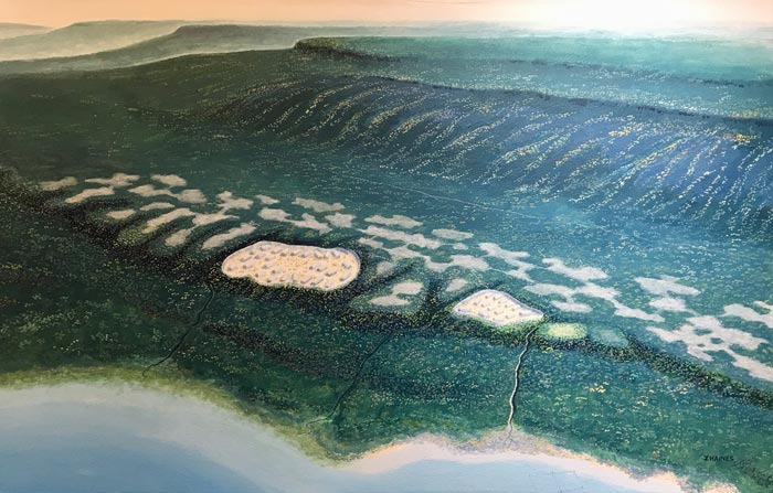
| 1791 | The Indians in the northern Great Lakes region do not have it easy: the soil is not very fertile and the climate is harsh. In addition to the wild water rice that the Indians gathered in the rice swamps along the Great Lakes, they hunted pigeons, martens, moose, caribou, beaver, muskrats, otters, caribou, gulls, cormorants, pheasants, bears, ducks, geese, swans and rabbits. Birds such as gulls and cranes were also smoked. Caribou were found in large numbers between Lake Winnipeg and Hudson Bay (Manitoba and Ontario, Canada). West and south of Lake Winnipeg, many bison lived on the prairies. Caribou were never found in bison territories and vice versa. Sturgeon, trout and whitefish were caught in the lakes and rivers. In the Mouse River area north of North Dakota in Manitoba (Canada), maple sugar was produced in spring. The sap extracted from the trunk of the sugar maple (also known as the river maple) was boiled over a fire. Birch trunks were used to make troughs for sap production. From around 1810, game became increasingly rare, probably due to the increasing presence of whites in the region, and the Indians began to grow corn to get through the winter. | - | - |
 | |||
| Overview of the nutritional basis of the Indians of North America. Source: Article about the traditional cultures of the Indians of North America - http://www.friedrich-verlag.de/pdf_preview/d56117_0411.pdf. | |||
| 1796 | The English built Fort Malden near Amherstburg in Ontario at the mouth of the Detroit River into Lake Erie. | - | - |
| 1802 | As a result of the Peace of Paris in 1783, Fort Niagara suddenly found itself on American territory and had to be evacuated by the British. Within sight of the fort, the British built Fort George in 1802. | - | - |
| Winter 1809 | It was a hard winter for the Indians in the Great Lakes region. The USA reduced its trade with the French and English and their allies (the Indians) to such an extent that the Indians felt their dependence on trade goods such as metal kettles, ammunition, lead, gunpowder etc.. Game had already become very rare by this time. | Shawnee | - |
| End of Frühling 1810 | Tecumsehs Journeys 1806-1812 - Tecumseh turned northeast toward the Ottawa, Potawatomi, Ojibwe, Shawnee, and Wyandot villages of Maguaga and Brownsville south of Detroit. | Kispoko (Shawnee) Ottawa Potawatomi Ojibwe Shawnee Wyandot | Tecumseh |
| 12 November 1810 | Tecumsehs Journeys 1806-1812 - Tecumseh again reaches Fort Malden in Upper Canada, accompanied by Potawatomi, Ottawa, Winnebago and Sac. He spoke with General Elliott. Tecumseh openly asked the British for support and rations in the fight against the Americans. He also announced his intention to travel to the south to gain the support of the Indians there. Tecumseh expected his Confederacy to be in place by the fall of 1811. Tecumseh expected a war against the Americans. The English were also heading for war against the Americans, but independently of the Indians, and as the correspondence between the government and the army shows, the English intended to stop supporting the Indians if the English alliance with the Indians became uncomfortable. | Kispoko (Shawnee) Potawatomi Ottawa Winnebago Sac | Tecumseh |
| About 1810 | Large parts of the Ojibwe tribal area were barren and inhospitable. Maize could hardly be grown in their area, if at all. The dried meat often did not last through the winter. Time and again, famines occurred in winter and people died of hunger. Even the strongest men and best hunters could starve to death in winter. | Ojibwe | - |
| Begin of August 1811 | Tecumsehs Journeys 1806-1812 - A delegation from Tecumseh reaches the Iroquois at Buffalo Creek, now Niagara, where the Iroquois held their council meetings. After the end of the American Civil War, however, the Iroquois remained quiet and were only a shadow of their former selves. Many Iroquois left the United States for Canada, and those who remained lived surrounded by whites. The delegation was not without success. Some Iroquois joined Tecumseh as late as 1811, others followed in 1812, but many Iroquois chiefs received annual payments from the Americans and therefore held back their warriors. | Kispoko (Shawnee) Iroquois | Tecumseh |
| 13 March 1812 | A delegation of 8 Shawnee, 8 Winnebago and 8 Kickapoo asked General Elliott in Fort Malden (Canada) for weapons, gunpowder, ammunition and food. However, the general had been instructed by the British government not to cooperate with the Indians and only gave them a few foodstuffs. One of the reasons why the Indians defected to the English rather than the Americans was that the Americans did not provide the Indians in the reservations on their territory with sufficient food. The rations were often too low and the credit system introduced meant that the Indians became increasingly indebted. The English, on the other hand, like the French before them, were more generous and not as devious and land-hungry as the Americans. | Shawnee Winnebago Kickapoo | - |
| 21 June 1812 | Tecumseh once again came to Fort Malden, today's Amhersburg near Detroit in southern Ontario, and again tried to persuade the British to wage war against the USA. He also visited the Wyandot, Ottawa and Ojibwe living in the surrounding area on the Detroit River. | Kispoko (Shawnee) Wyandot Ottawa Ojibwe | Tecumseh |
| 7 July 1812 | A conference is held in Fort Malden between Lieutenant Colonel Thomas St. George and Tecumseh, who has arrived with 200 Indians. The conference itself leads to no result. During the conference, however, Tecumseh receives an invitation to a great council in Brownstown, arranged by Walk in the Water, the chief of the three Wyandot and Shawnee villages on the American side of the Detroit River. Tecumseh declines. | Wyandot | Walk in the Water |
| 12 July 1812 | General Hull Offensive 1812 - General Hull crossed the Detroit River and occupied the town of Sandwich in Upper Canada without resistance. The Ojibwe of the St. Clair River (St. Clair River Rapids near Port Huron) and the Iroquois of the Grand River sent delegates to General Hull and asked for protection from the English in return for their neutrality. | Kispoko (Shawnee) Iroquois Ojibwe | Tecumseh |
| 12 July 1812 | General Hull crossed the Detroit River and occupied the town of Sandwich in Upper Canada without resistance. The Ojibwe of the St. Clair River (St. Clair River Rapids near Port Huron) and the Iroquois of the Grand River sent delegates to General Hull and asked for protection from the English in return for their neutrality. | - | - |
| Middle of 1812 | General Hull Offensive 1812 - The Ojibwe lived on the St. Clair River Rapids near the present-day village of Point Edward in Ontario. | Ojibwe | - |
| 16 July 1812 | General Hull Offensive 1812 - General Hull suddenly appeared at the Aux Canard River with 280 soldiers under the command of Colonel Lewis Cass. The English had not even considered it necessary to destroy the bridge over the river. Cass managed to occupy the bridge undisturbed, cross the river and stand at the gates of Fort Malden. The Indians expected a hard fight the next morning and danced the night away. But the next morning - hard for the English and Indians to believe - the Americans had retreated back to Sandwich! Hull suddenly hesitated to advance. He had too much respect for the Indians and the cruelty they could inflict on the soldiers. Due to Tecumseh's 'everywhere and nowhere' tactics, they had completely overestimated the strength of the Indians. This behaviour had a demoralizing effect on the American soldiers and chiefs. | Kispoko (Shawnee) | Tecumseh |
| 25 July 1812 | General Hull Offensive 1812 - Major James Denny and 120 volunteers from Ohio were ambushed by Tecumseh between the Aux Canard River and Turkey Creek, which ended with a wild escape by the militia. The Americans were only able to save themselves by making a very quick escape to Turkey Creek. Denny had 5 dead, 2 wounded and one missing. Tecumseh's losses amounted to 1 dead and 3 wounded. Tecumseh quickly realized that the troops were militia, who were disorganized much faster in battle than regular soldiers and were therefore easier to fight. | Kispoko (Shawnee) Ottawa Potawatomi | Tecumseh |
| 8 August 1812 | General Hull Offensive 1812 - General Hull decided to withdraw all but 250 soldiers from the occupied town of Sandwich and concentrate them in Fort Detroit. This ended the American invasion of Upper Canada. | Kispoko (Shawnee) | Tecumseh |
| 13 October 1812 | The Americans crossed the Niagara River at Queenston with 900 regular soldiers and 2270 militiamen. On Queenston Heights, the Americans captured an English artillery position. General Brook quickly gathered 300 soldiers and attacked the Americans. He was killed in the process. Major General Roger Sheaffe took command and attacked the Americans together with Mohawk warriors under John Norton. While the English advanced, the Mohawk fired on the Americans from a nearby forest. Shortly afterwards, the American order disintegrated. A short time later, the American troops surrendered. The Americans lost 500 soldiers and 900 were taken prisoner. The British lost 104 men. | Mohawk (Iroquois) Mohawk (Iroquois) | Joseph Brant John Norton |
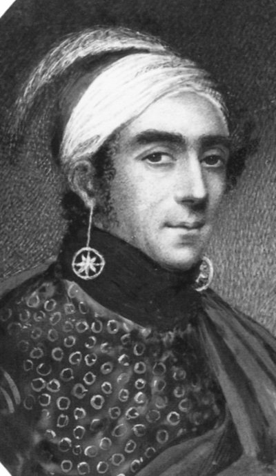 | |||
| John Norton led the Mohawk warriors into the Battle of Queenston Heights. Source: http://www.uppercanadahistory.ca/1812/18123.html. | |||
| 4 October 1813 | Proctor slowly retreated to the Thames River, but made no effort to dig a defensive position here, as he had promised! His warriors met Richard Mentor Johnsohn's regiment at McGregors Creek with 1,000 Kentucky militia and 2 6-pounders, but had to give way. Tecumseh was hit in the arm by a bullet. The British troops were widely scattered and gradually fell into the hands of the Americans: on October 3, the boats and ammunition on October 5. Proctor then set up the Moraviatown defensive position. | - | - |
| Spring 1880 | The government in Ottawa decided to replace Major Walsh, who had always treated the Indians with respect and understanding, with Lief Crozier. Crozier arrived at Fort Walsh on July 13, 1880 and took command. Crozier's tactic was to persuade the Lakota to return to the USA. | - | - |