


|
| Book cover | Autor | Title | Description |
| Bild | Autor | Leer | Beschreibung |
| Date | Event | Tribe | Chief |
| February - März 1822 | Ashley's Hundred 1823 - William Ashley placed several advertisements in the St. Louis newspapers. He was looking for 100 experienced adventurers to travel with him up the Missouri River to its source. Ashley mainly wanted to hunt beaver there. Ashley had a five-year license for trading rights in the area along the Missouri River. The expedition was to start in 1823. Famous personalities such as Jerediah Smith, Jim Bridger, Hugh Glass and Jim Beckwourth responded to the advertisement. | - | - |
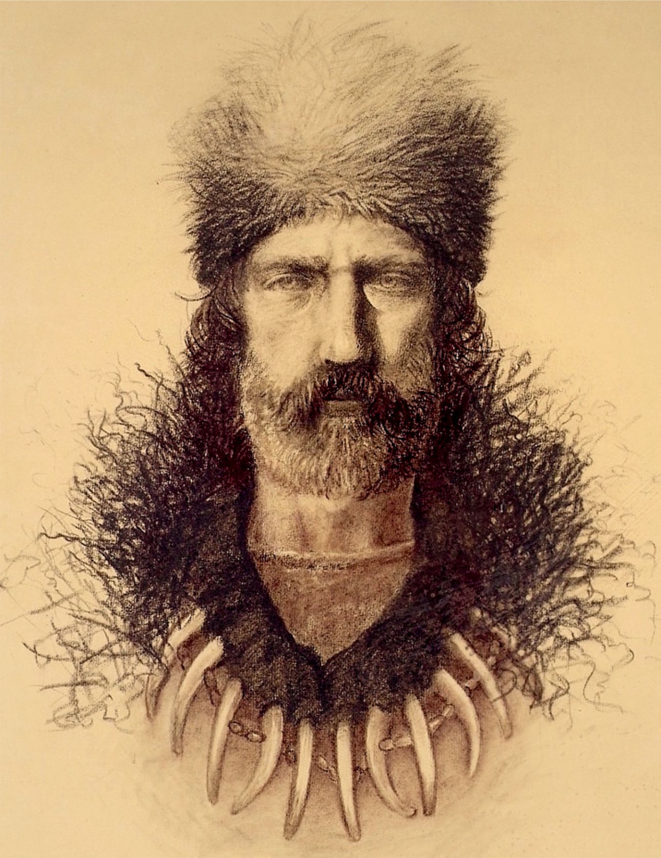 | |||
| Hugh Glass. Source: http://historythings.com/historys-badasses-hugh-glass/ | |||
| Middle of August 1823 | Ashley's Hundred 1823 - Ashley reached Fort Kiowa with his men. From there he sent a group of about 30 men under the leadership of Andrew Henry to Fort Henry at the mouth of the Yellowstone River. Fort Henry was to be closed and the men were to spend the winter with the Crow Indians. Hugh Glass marched with the group. | Crow | - |
| 20 August 1823 | Andrew Henry was attacked by Hidatsa 1823 - Ashley's Hundred 1823 - Andrew Henry's group was attacked at night by Hidatsa Indians at the end of August (according to the diaries of Potts and Moses, 2 members of the group). 2 men were killed, 2 wounded. Henry sent the wounded back to Fort Kiowa and marched on with 15 men. | Hidatsa | - |
| End of August 1823 | Ashley's Hundred 1823 - About 3 miles southwest of Shadehill on the Grand River in northern South Dakota, Hugh Glass unexpectedly encountered a grizzly bear. The grizzly seriously injured Glass. 2 companions, Jim Bridger and John Fitzgerald, stayed with Glass to bury him after his death. When Indians came into sight 3 days later, Bridger and Fitzgerald left Glass and made their way back. They covered Glass with a bearskin and took his weapons and equipment. But Glass was not dead. He made his way to Fort Kiowa. | - | - |
 | |||
| Bear attack on Hugh Glass. Source: Wikipedia. | |||
| 31 December 1823 | Ashley's Hundred 1823 - Glass reached the new Fort Henry at the mouth of the Bighorn River. There he met Jim Bridger. Glass forgave Jim Bridger for abandoning him after the bear attack. Fitzgerald was not at the fort. | - | - |
| 29 February 1824 | Ashley's Hundred 1823 - Glass, Marsh, Chapman, More and Dutton left Fort Henry with a message for William Ashley, who was in St. Louis. The group marched along the Powder River to the Platte River and from there to Fort Atkinson. | - | - |
| 1 July 1825 | The first Rocky Mountain Rendezvous took place on July 1, 1825 at Henry's Fork of the Green River in Wyoming. 91 trappers and fur traders attended. Some Cheyenne and Crow were also present. Among the participants were William Ashley, Jedediah Smith and Jim Bridger. | Cheyenne Crow | - |
| June 1826 | The second Rocky Mountain Rendezvous took place in Cache Valley, Utah. | Cheyenne Crow | - |
| June 1827 | The third Rocky Mountain Rendezvous took place at Bear Lake in Utah. Blackfoot Indians attacked the rendezvous, the battle lasted over 6 hours. | Blackfoot | - |
| July 1827 | The fourth Rocky Mountain Rendezvous again took place at Bear Lake in Utah. Once again, Blackfoot Indians attacked the rendezvous. However, they were repulsed with the help of several hundred friendly Indians. | Blackfoot | - |
| July 1829 | The fifth Rocky Mountain Rendezvous took place north of Lander on the Little Wind River in Wyoming. | - | - |
| 18 July 1832 | In the Pierre's Hole area, a Blackfoot chief was shot and killed as he approached the rendezvous at Pierre's Hole with peaceful intentions. The Blackfoot attacked the 40 Trappers, Nez Perce and Flathead. In the ensuing battle, 7 Nez Perce or Flathead, 6 Trappers and 9 Blackfoot died. The Nez Perce chief, Lawyer, was wounded by a rifle bullet. More than 20 years later, this injury would still bother the chief. | Nez Perce Flathead (Salish) Blackfoot | Lawyer |
| 8 July 1842 | John Charles Fremont Expeditions 1842-1846 - The second group of the Fremont Expedition under Charles Preuss (with Kit Carson as guide) encountered a large group of traders and trappers led by Jim Bridger. Bridger warned Preuss of hostile Lakota, Gros Ventre and Cheyenne who were in the Red Buttes area (west of the present-day town of Casper). | Lakota Cheyenne Gros Ventre | - |
| 1843 | Jim Bridger and Louis Vasquez began building Fort Bridger. The fort became a trading post and stopping point for immigrants to California and Oregon. | - | - |
| 17 September 1851 | Treaty of Fort Laramie 1851After the dispute with England over the boundary of the state of Oregon was settled in 1846 and gold was discovered in California in 1848, long wagon trains began to travel along the Platte River to Oregon and California. The government hoped that the treaty would reduce raids on the wagon trains. The treaty stipulated that the Great Plains belonged to the Indians as long as 'the rivers flow and the eagles fly'. In return, it was agreed that the Oregon Trail could be used by the white immigrants. In return, the Indians were to receive annual payments of 50,000 US dollars for the next 50 years. The treaty also permitted the construction of forts and roads on Indian territory. The Senate ratified the treaty in 1853 with one amendment: the payments were to last only 10 years. All tribes except the Crow agreed. The Treaty of Fort Laramie of 1851 is also known as the Horse Creek Treaty. Since more than 10,000 Indians showed up for the treaty negotiations with at least as many horses, the negotiations were moved to the mouth of Horse Creek, about 30 miles east of Fort Laramie. Many tribes never received the agreed upon annual payments. Over the next 10 years, a series of forts were built along the Platte River. Then came the wagon trains, the stagecoaches, then the pony express riders, and finally the telegraph poles. As a result, first the game and then the bison were gradually driven out of the area. In 1858, gold was discovered at Pike Peak and immigration increased, and it was agreed in the treaty that the Great Plains would belong to the Indians as long as 'the rivers flow and the eagles fly'. In return, it was agreed that the Oregon Trail could be used by the white immigrants. In return, the Indians were to receive annual payments of 50,000 US dollars for the next 50 years. The treaty also permitted the construction of forts and roads on Indian territory. The Senate ratified the treaty in 1853 with one amendment: the payments were only to be made for 10 years. All tribes except the Crows agreed. Many tribes never received the agreed upon annual payments. Many forts were built along the Platte River over the next 10 years. Then came the wagon trains, the stagecoaches, then the pony express riders and finally the telegraph poles. This drove the deer and bison out of the region. In 1858, gold was discovered on Pike Peak, south of Denver, Colorado, and immigration continued to increase. Under the treaty, the tribes undertook to no longer wage war against each other. The treaty also set fixed boundaries for the tribes. It can be assumed that the Indians hardly knew what they were actually signing. It was inconceivable that the Hunkpapa, for example, would suddenly stop waging wars against the Crow and Assiniboine. These traditions had become too engrained in the lives of the Indians over the last few centuries. As a result of the treaty, the tribal territory of the Crow Indians of 144,000 km. The contract provided for several payments. However, the US government only made one payment and thus breached the contract. The Assiniboine were given a reservation between the Musselshell River and the Yellowstone River. | Oglala (Lakota) Crow Assiniboine Shoshone Brule (Lakota) Arapaho Gros Ventre Southern Cheyenne (Cheyenne) Brule (Lakota) Arikara Hidatsa Mandan Assiniboine Assiniboine | Big Robber Little Owl White Antelope Conquering Bear Iron Bear Four Bears White Wolf First Fly Crazy Bear |
| June 1864 | John Bozeman and Jim Bridger independently organized wagon trains from Casper (Wyoming) to the gold fields of Virginia City (Montana). John Bozeman's route led through the Powder River area east of the Bighorn Mountains. At present-day Sheridan in northern Wyoming, the route entered Montana, where the Powder River and the Big Horn River had to be crossed. The route continued along the Yellowstone River to Virginia City. The route led right through the hunting grounds of the Lakota, Cheyenne and Arapaho. According to the Treaty of Fort Laramie of 1851, this area belonged to the Indians. Jim Bridger knew the Indians very well and therefore chose a route west of the Bighorn Mountains to Virginia City. This route was a few weeks faster and did not pass through the most important hunting grounds of the Plains Indians on the Powder River. However, this route was much more challenging than John Bozeman's. This is why John Bozeman's route prevailed. The route became known as the Bozeman Trail. The Bozeman Trail had a length of 680 miles. The use of the Bozeman Trail from 1865 by white settlers, gold seekers and adventurers led to the army being given the task of protecting the white wagon trains from the Indians. The invasion of Colonel Carrington with eight companies of the 18th Infantry in May 1866 into the Prairie Indians' most important remaining hunting grounds led directly to the 'Red Cloud War'. | Oglala (Lakota) Northern Cheyenne (Cheyenne) Lakota | Red Cloud |
 | |||
| Bozeman Trail. Source: http://www.plentycoups.org/ | |||
| 29 August 1865 | Battle on the Tongue River 1865 - Powder River Expedition 1865 - General Patrick E. Connor attacked the village of Black Bear with 250 tents on the Tongue River with 250 soldiers and his Pawnee scouts in northeastern Wyoming. Jim Bridger was also present as a scout for Connor during this attack. The Indians had to retreat 10 miles across Wolf Creek and attacked Conner again from there, but the now numerically superior Arapaho were kept at bay by the use of Howitzer cannons. The Arapaho lost 64 warriors and many women and children. The 1000 or so ponies that had initially been driven away by the soldiers were recaptured. In total, the Arapaho lost their entire household, including their tents, bison skins, tent poles and around 30 tons of dried bison meat for the winter. Conner found the camp because he was following a Cheyenne Indian who was carelessly on his way to the Arapaho with his wife despite these warlike times! The result of this raid was that the Arapaho allied themselves even more closely with the Lakota and Cheyenne and fought fiercely in subsequent battles such as Fettermann, Rosebud and at the Little Big Horn. | Arapaho Pawnee | Black Bear |
| 29 August 1865 | Battle on the Tongue River 1865 - Powder River Expedition 1865 - General Patrick E. Connor, with 250 soldiers and his Pawnee scouts, attacked the village of Black Bear with 250 tents on the Tongue River in northeastern Wyoming. Connor found the camp because he was following a Cheyenne Indian who, despite the warlike times, was on his way to the Arapaho with his wife without a care in the world! Jim Bridger was also there as a scout for Conner during this raid. The Indians had to retreat 10 miles across Wolf Creek and attacked Conner again from there, but thanks to the use of Howitzer guns, the now numerically superior Arapaho were kept at a distance. The Arapaho lost 64 warriors and numerous women and children. The approximately 1000 ponies, which had initially been driven away by the soldiers, were recaptured. In total, the Arapaho lost their entire household, including their tents, bison skins, tent poles and around 30 tons of dried bison meat for the winter. As a result of the raid, the Arapaho became even more closely allied with the Lakota and Cheyenne and fought fiercely in subsequent battles such as Fettermann, Rosebud and Little Big Horn. | Arapaho Pawnee | Black Bear |
 | |||
| Information on the Conner Battlefield near present-day Ranchester in the far north of Wyoming. Source: Thomet Daniel 2009. | |||
| 3 August 1866 | From Fort Phil Kearny, Companies D and G, under the command of Captain Nathanial Kinney, left Fort Phil Kearny heading north. Their mission was to find a suitable site for a third fort (in addition to Phil Kearny and Fort Reno) along the Bozeman Trail. Jim Bridger was there as a scout. Fort C.F. Smith was built about 90 miles northeast of Fort Phil Kearny. | Oglala (Lakota) | Red Cloud |